This article is currently under construction.
Introduction
"An airway is a legally defined corridor that connects one specified location to another at a specified altitude, along which an aircraft that meets the requirements of the airway may be flown." (read more of this definition here)
In Second Life there is no established protocol regarding the airways and the altitude at which they must fly according to the direction to which you go. In fact, although recommended levels of flight were established, the obstacles that are in the skies of SL are as unexpected as a boat, a house or other remains of airplanes or helicopters that are abandoned.
When I started to build Air Maps Routes, most of the pilots of SL had the knowledge that 100 meters above ground level could escape the ban lines, but there were still other factors such as full sims, the orbs security or plots closed to a list of members (they will teleport to your base without giving time to leave).
Fly with many obstacles you can remove the desire to do it, but few pilots who like risk we have decided to throw vacuum and enjoy the unexplored.
Therefore, the air routes that I designed for the year 2015 have been extended to more areas of the present continents, like the waypoints have been modified in quantity and names.
The original creator of the routes, Lobofeo Kobaleinen, established a series of air routes in a very small area, looking back six years ago the aforementioned problems, which had restricted the fly zones; Today we can use existing knowledge to avoid these problem areas.
Then I will outline the current air routes and their corresponding waypoints, also recommended levels for each flight routes; also comments trouble spots such as concrete step forward without these affect us included. Finally indicate that the heights are in meters (FL 250 is equal to flight level 250 meters) and the directions are also indicated: HDG 090 (same direction at 90 degrees), And one last tip: always flight in half of the region, unless otherwise stated in flight advisories.
Some ideas about airways, routes and waypoints
For use in aviation in Second Life, we could say that a "AIRWAY" is a general route indicating areas where there are waypoints and airports, usually being indicated by the letter "V" followed by the letter "A" and two numbers ( the VA00 or V-A00 corresponds to the airway that runs through Satori); a 'Waypoint "can be defined as a point of geographic location indicated in a general route for a word five letters being formed commonly (Thuul is a waypoint near the airport of New Horizons) or through the geographic location used in SL (for example, 1125, 1045 corresponds to the region of Alphubel); finally a "ROUTE" is a sequence of waypoints that lead about a particular airport or a waypoint that links to other routes and indicated with an "R" followed by one, two or three numbers and a final word indicates the geographic direction toward which it goes, for example north, south, east or west (eg; R51E indicates that we go eastward and would be made up of several waypoints, being reflected in a flight plan as SLNH> R01E> SLHA and do the reverse route as SLHA> R51W> SLNH).
When we flight in regional routes (short duration in time or kilometers) we can use the classic flight plan with departure airport code, waypoints and arrival airport code (SLNH> Thuul> WINDS> TTATT> SLHA) but if we are to make intercontinental flights from Satori's north coast to the south coast of Gaeta V, it is best to use a combination of designated routes (SLNH> R23N> R35E> R36N> R40E> SLWP).
On a personal level, I would like to offer a number of air routes that are a guide to follow when making flight plans, but I guess not everyone will agree to standardize these routes; I am currently working with Kelly Shergood in the creation of these routes for use with your map, and I think we have different approaches to the same topic ways, but I imagine it could establish a general protocol to make flight plans, that even using each one a different system of some help to all aviators, that's the last mission we all have for our map and instruments always be helpful. Thanks to Kelly Shergood, Freezing Sorbet and all airmen and groups that help improve the flight in Second Life.
Note: Currently, we start making the routes (the above routes being only an example); we indicated in this page the routes to be designated for use in flight plans.
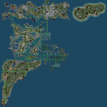
The lasts Ananda´s maps
Here is the latest version of the maps with the airways in mainlands with airports most visited; I made this in April 15, 2013.


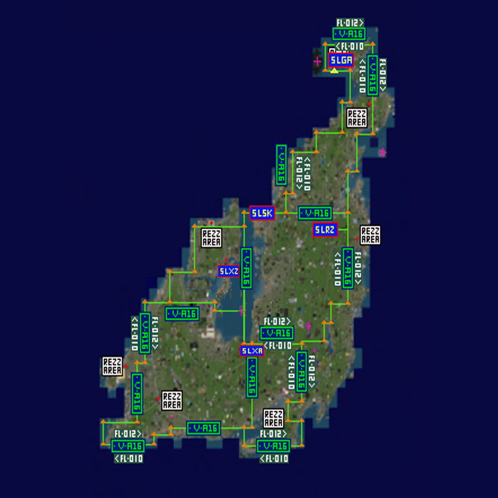
Airways, waypoints and routes in the big supercontinent of SBNCG (updated to March 16, 2015)

download the map in a full definition here